
Just as the Bay Area’s prolific wild grasses are starting to turn brown and dry for summer, the city of Berkeley is out the gate with an ambitious new wildfire prevention strategy.
“It’s a whole new ballgame,” said Councilmember Susan Wengraf, whose district includes much of the city’s greatest wildfire hazard neighborhoods.
“It should have been started a long time ago,” said Councilmember Sophie Hahn, whose district also includes high fire risk areas.
More than a year in the making, Berkeley’s Community Wildfire Protection Plan, accepted by the City Council at its Tuesday meeting, is based on resident surveys, updated wildfire data, state laws and input from several departments including police, public works, parks, and the city manager’s office. It’s housed in the city’s fire department, specifically in its new wildland urban interface (WUI — woo-ee) division.
It includes several first-ever-in-Berkeley action steps, including:
- A volunteer force of wildfire prevention ambassadors, to help residents understand vegetation management (defensible space) requirements.
- Free cut-to-order ember catching mesh wire to cover chimneys and gutters for property owners required to maintain defensible space. Installment isn’t included. A pilot program will soon roll out to targeted parcels based on risk.
- Detailed, comprehensive home inspection reports (with photos) using the Fire Aside software program. Inspectors enter data into tablets in the field, including both requirements and recommendations. Reports can be more than a dozen pages long, depending on the property.
- A pilot financial assistance program for property owners struggling to bring their yards into compliance due to finances or disability. The assistance will be one-time, to help people meet defensible space requirements, but isn’t intended for ongoing maintenance. Fire staff will help identify property owners, who must apply for the aid. The application process is still being finalized. Results will guide whether and how to grow the program.
- Increased wildland fire staff, including paid student property inspection interns, hired under the city’s Youthworks program. Two are working now, with seven more to start in June.
- A real-time evacuation traffic study, which could begin as soon as next week and will guide the city’s slowly unfolding Safe Passages parking and traffic plan for the hills.
- Household wood chipper and brush disposal services by appointment.
- Installation of a new outdoor warning system across the city, with sirens and programmable talking. Five are up so far, with plans to install 10 more over the next year.
- A new 3,000 gallon water tanker truck that can be used for any blaze in the city or the adjacent wildland areas that have no water supply infastructure.
- Supporting neighborhoods in becoming Firewise communities, a certification of the National Fire Protection Association based on collective preparedness. Some insurance companies lower homeowner coverage costs for properties in Firewise communities. Berkeley now has five certified Firewise neighborhoods — Acacia, Park Hills, San Diego-Indian Rock, Boynton-Florida, and Fairlawn — with another 15 neighborhoods working on certification.
- A new Fire Department website.
- A new public information officer for wildfire education and outreach.
Citing climate change and extreme weather patterns that make catastrophic fires more likely, newly confirmed Berkeley Fire Chief David Sprague said the area’s high wildland fire risk “is not something we can ignore [or] something that’s going to get better.”
It’s impossible to change the city’s climate, topography or weather, he said. But vegetation can be changed.
In line with the state, the city’s new plan emphasizes defensible space requirements to thin, trim and clear grasses, brush and trees from around structures extending out 100 feet in all directions, with the strictest standards closest to houses.
Property owners in the state’s highest hazard wildfire zones are required by law to maintain defensible space, with the rules being enforced during the driest months of the year when wildfire risks skyrocket.
In Berkeley, this applies to an estimated 8,500 properties, forming a swath of vulnerable neighborhoods marked by steep slopes, thick vegetation, and houses relatively close to each other.
The city’s plan considers risks from wildfire to all areas of Berkeley, such as traffic congestion in an evacuation, but is primarily focused on areas with the most severe wildfire hazard, Berkeley’s fire zones 2 and 3, located in the hills and close to open space.
The state establishes wildfire hazard severity zones based on various data such as weather, topography, density, and vegetation, with most of the Berkeley Hills falling under the high and very high hazards. The city also establishes its zones, taking into account hyperlocal factors such as dead-end streets. The two largely overlap. Local wildfire laws can be stricter, but not weaker than state law.
Most property owners have been living with defensible space regulations for a few years, since enacted by the state in 2019. Enforcement is the responsibility of local fire agencies. Noncompliance results in citations.
Indeed, the city has been moving toward more aggressive wildfire preparation for a few years, with a significant boost by Measure FF, an $8.5 million emergency response and preparedness parcel tax passed by voters in 2020 that specifically earmarked money to address wildland fire risks. The new wildfire plan is funded primarily through Measure FF.
In 2022, Berkeley was one of four cities in the state named as a Fire Risk Reduction Community, by the state Board of Forestry and Fire Protection. Agencies that “meet best practices for local fire planning” are awarded the distinction. The others are Sonora, Rancho Cucamonga, and Corona. The counties of Butte, Los Angeles and Santa Barbara were also named, along with several non-city or county agencies including the East Bay Regional Park District and the East Bay Municipal Utility District.
But the hope, Sprague said, is that the new wildfire plan’s enhanced property inspections and education, boosted staffing (including more inspectors), and programs to assist residents such as ambassadors, financial help, and curbside chipping will result in greater voluntary compliance — both with requirements and beyond.
In the past, according to city numbers, the majority of properties comply with the regulations, but there are stragglers and challenges, even with fines.
“We know we’ve got a significant amount of education to conduct,” Sprague said.
In its new plan, the city is upping the bar.
Required work will be enforced. The city is also educating property owners about recommended yard and house prevention (called home hardening) steps that go beyond current laws, but are based on data. Inspection reports will include recommendations.
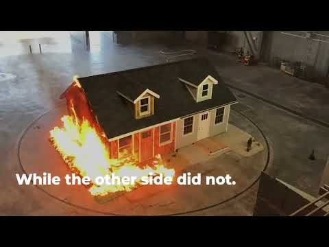
For example, these suggestions will cover defensible space Zone 0, extending out 5 feet from the base of structures. Often referred to as the ember-free zone, the state is poised to enact new, strict vegetation requirements for higher fire hazard areas that include most of the Berkeley Hills.
Zone 0 is already law. The regulatory details, or exact requirements, are being worked out by the state Board of Forestry and Fire Protection.
Hardscaping such as gravel, concrete or rock is the gold-standard for Zone 0, to diminish the chances of embers igniting into flames. But based on recent drafts of the regulation, the state is likely to allow some vegetation in the zone, with requirements for height, spacing and maintenance.
Scroll down to see Berkeley Fire’s guidance on defensible space zones
Berkeley Fire is encouraging property owners to start incorporating Zone 0 in their defensible space work now, not only to get a jumpstart on the law, which should take effect in a year or two (first for new construction, and a year later for existing structures), but, Sprague said, because convincing data shows this is one of the most significant steps homeowners can take to prevent their houses from blowing up into flames in a wildfire.
A demonstration garden featuring Zone 0 landscaping is being installed at the city’s fire station No. 4, at The Alameda and Marin Avenue.
“We know we’re asking homeowners to do an incredible amount of work, in some cases, removing vegetation that has been growing for decades,” Sprague said.
“We’re anticipating there’s going to be a huge amount of pushback and people are upset at the work that we’re asking them to do, especially within 5 feet of their home, because we’re all used to having lush dense vegetation around our homes,” Sprague said. “That’s going to have to change.”
Another aspect of Berkeley’s wildfire plan that could be challenging, Sprague said, is the requirement, now in city law, for the 100 feet of defensible space to be property line blind.
In other words, regardless of where a property line falls, 100 feet from any structure must meet defensible space requirements, which means, in some cases, neighbors must work with neighbors on compliance.
“Fire does not respect parcel boundaries,” Sprague said. “As a homeowner you need to look across your property lines to your neighbors’ homes, and make sure you’re doing the appropriate amount of vegetation management.”
Sprague called this a “nuanced part of the [city] code that’s really, really important.”
“That’s going to take a couple of years for people to really understand and grapple with what it means,” he said.
An underlying premise of the wildfire plan is working with residents, and using education as a motivator.
To this end, the wildfire ambassadors are primarily residents of high hazard fire areas, trained to teach others. So far, the city has 12 ambassadors. “They receive training and then essentially go door to door in the fire zones to spread the word on what needs to happen and where residents can get more information,” Sprague said.
Inspections are underway and will continue through summer.
“The city of Berkeley is doing literally everything that can be done. . . as much as is conceivable,” Wengraf said.
The real test of the plan will be measured in neighborhoods, she said. “The community outreach and involvement implementation is what will distinguish our efforts.”
At the council meeting Tuesday, Wengraf asked if the real time evacuation study, slated to start next week, could be done when UC Berkeley is in session, or at least revisited then. And Councilmember Mark Humbert, whose district includes Panoramic Hill, designated as the part of the city with the most severe wildfire hazard, asked if the plan can include another access route in or out of the hillside neighborhood, which faces serious evacuation bottlenecks with only one road in and out. Sprague said he would follow-up on both requests, though he doubted if the wildfire plan was the appropriate approach for a new roadway for Panoramic Hill.
The overall goal of the plan, Sprague said, is “to massively overwhelm [wildfire] with resources.”
“We’ve come a long way since 1991,” he said, referring to the deadly Oakland and Berkeley hills Tunnel Fire.
Berkeley Fire guidance on defensible space
Zone 0 — Ember resistance (0-5 feet)

The first five feet from your home is the most important. Keeping the area closest to buildings, structures, and decks clear will prevent embers from igniting materials that can spread the fire to your home.
Why? The majority of homes lost to wildfire are ignited by flying embers. Embers can travel miles ahead of the active front of wildfires.
What to do:
- Use hardscape like gravel, pavers, or concrete. No combustible bark or mulch.
- Remove all dead and dying plants, weeds, and debris (leaves, needles, etc.) from your roof, gutter, deck, porch, stairways, and under any areas of your home.
- Remove all branches within 10 feet of any chimney or stovepipe outlet.
- Limit combustible items (like outdoor furniture and planters) on top of decks.
- Relocate firewood and lumber to Zone 2.
- Replace combustible fencing, gates, and arbors attached to the home with noncombustible alternatives.
- Consider relocating garbage and recycling containers outside this zone.
Consider relocating boats, RVs, vehicles, and other combustible items outside this zone.
Zone 1 — Lean, clean and green (5-30 feet)

Regularly clear dead or dry vegetation and create space between trees. During times of drought when watering is limited, pay special attention to clearing dead or dying material.
Why? Removing dead plants and creating space between trees and shrubs creates a buffer for your property and reduces potential fuel for fire.
What to do:
- Remove all dead plants, grass, and weeds.
- Remove dead or dry leaves, pine needles and eucalyptus slash.
- Trim trees regularly to keep branches a minimum of 10 feet from other trees.
- Create a separation between trees, shrubs, and items that could catch fire, such as patio furniture, wood piles, swing sets, etc.
If this zone extends into a neighbor’s yard, work together to coordinate actions and enhance the value of the collected efforts.
Zone 2 — Fuel reduction (30-100 feet)
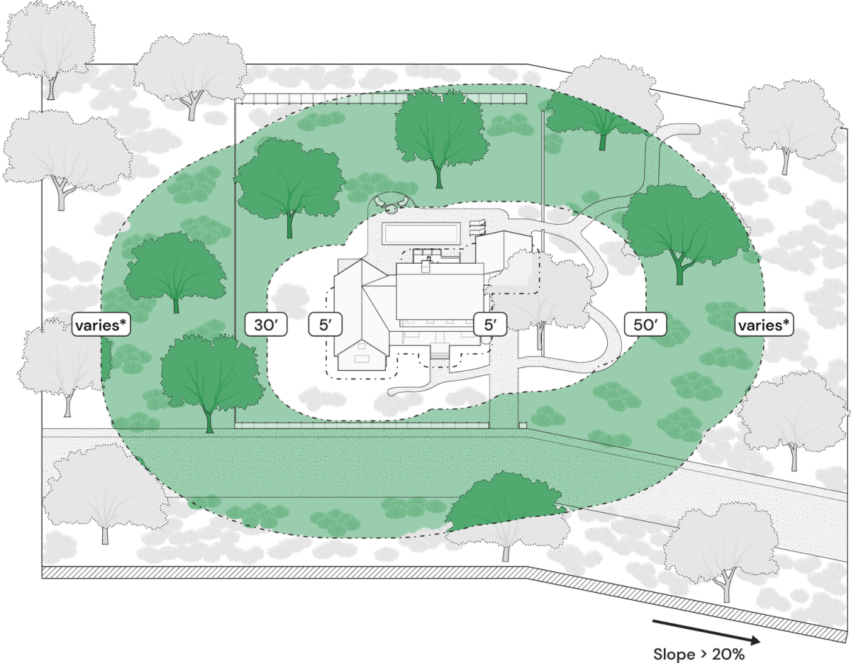
Continue reducing potential fuel within 100 feet or the property line. If this zone extends into a neighbor’s yard, work together to coordinate actions and enhance the value of the collected efforts.
Why? 100 feet of defensible space is required by law.
What to do:
- Cut or mow annual grass down to a maximum height of four inches.
- Create horizontal space between shrubs and trees.
- Create vertical space between grass, shrubs and trees. (See diagram)
- Remove fallen leaves, needles, twigs, bark, cones, and small branches. However, they may be permitted to a depth of three inches.
- Keep 10 feet of clearance around exposed wood piles, down to bare mineral soil, in all directions.
- Clear areas around outbuildings and propane tanks. Keep 10 feet of clearance to bare mineral soil and no flammable vegetation for an additional 10 feet around their exterior.
Learn more about defensible space on the Berkeley Fire website.
