

At 3:30 a.m. on Jan. 15, Rick Wilson was awakened from a deep sleep by a text. Not from a friend in distress or someone trying to sell car insurance, this message came from the National Tsunami Warning Center in Palmer, Alaska, saying it was evaluating an imminent threat to the West Coast.
For Wilson, an engineering geologist, this was a call to work. The Sacramento resident runs the Tsunami Unit of the California Geological Survey, a division of the state’s Department of Conservation.
No stranger to late-night texts about impending tsunamis, Wilson said the vast majority of messages from Alaska’s warning center, one of a few in the country, say California is not at risk.
An “evaluation” notification is different: It’s a call for immediate attention.
“That’s the indication that we may be ramping up to a situation that may be dangerous,” Wilson said. The Geological Survey works closely with the California Governor’s Office of Emergency Services (Cal OES), and with cities and counties, to manage natural disasters.
Last Saturday’s event, Wilson soon learned, was a volcanic eruption near the Pacific island of Tonga. The undersea eruption forced a massive vertical column of seawater and lava sky high, with gravity smacking it back down into the ocean, triggering a pulsing wave outward – the tsunami.
Early data indicated California could face a coastal surge of up to 3 feet of water. This prompted a statewide tsunami “advisory,” which went out in the dark of the morning in a string of emails and zoom meetings from the National Tsunami Warning Center and state Tsunami Unit to Cal OES, National Weather Service bureaus and key local emergency contacts. Updates were sent throughout the day.
There are several types of tsunami alerts, according to the National Weather Service, including a watch, an advisory and a warning. A predicted water rise above 3 feet prompts a warning, which is the highest level of risk.
In tsunami terms, anything under 1 foot usually isn’t dangerous. But a higher rise raises eyebrows – and attention – from emergency responders, especially for potential impacts on people or structures in the water or in low-lying areas along the shore. In tsunami science lingo, it’s called the inundation zone.
The prediction, it turned out, was accurate. Tidal gauges in the inner Bay Area, including in Alameda and Richmond, the two closest to Berkeley, showed a roughly 27-centimeter or almost 1-foot water level rise. The surge was higher on the Bay Area’s outer shores.
Wilson characterized it as a “really small event.” But, for emergency responders, even this level of wave can cause damage, knocking boats around and flooding low areas near the water.
It’s like a yellow flag call to action.
“It’s more of a hazard to harbors or people in or on the water,” Wilson said. That’s why the Tsunami Unit “recommended that beaches and areas around harbors be evacuated,” he said.
Local officials make their own decisions based on the information they receive from above, along with their knowledge of community vulnerabilities.
Berkeley’s decision to evacuate its marina was in line with state data, Wilson said. Last weekend, high tide was also a factor, as the tsunami arrived in the Bay Area around peak tide.
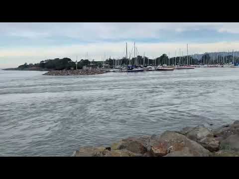
Wilson said his office was in direct contact with Berkeley emergency staff that day. And a Geological Survey engineer, who happens to live in Berkeley, he said, went to the marina to scope things out.
She captured footage of the seawater as it surged. Her video appears below.
Predicting tsunamis is a numbers game
Over the past 16 years, eight tsunamis have prompted an advisory or warning alert in California where a response of some kind was needed, Wilson said.
“This recent tsunami is probably the second or third largest or most impactful we have seen during that time,” he said.
After a triggering event such as an earthquake, volcano or major landslide, forecasting tsunami behavior such as speed, direction and size is getting more accurate, experts say, thanks to increasingly sophisticated technologies.
“Tsunami waves are pretty much predictable in terms of how fast they move across the surface; we can probably predict arrival time within 5 or 10 minutes,” Wilson said.
Most tsunamis travel at 500 mph, or the speed of a jet plane, he said. They slow down when they hit shallow water, forcing the energy upward, fueling larger waves. Tsunamis are usually a series of waves, pulsing toward shore.
There are always unknowns and margins of error, but tsunamis can offer a precious window of time for preparedness, depending on how far from shore they originate. The farther away, the longer the window.
Tonga, tragically, faced chaos, but the California coast had a few hours to prepare.
With tsunamis, there is real-time prediction of an event in action, and forecasting future events – or trying to determine how vulnerable a given area is to the unusual waves.
This prediction modeling, a sophisticated statistical analysis, works out probabilities based on factors such as past triggering events, plate tectonics and land formations. A primary goal of this modeling is to help emergency planners and responders.
“It’s an analysis of probabilities and uncertainties,” Wilson said.
Today, tsunami damage forecasting is based on what’s called a 1,000-year event, or the worst-case scenario going back 1,000 years in a given location. For the California coast, this is a 9.3 magnitude earthquake in the Alaska Aleutian Islands.
Preparing for this scenario should result in preparation for the worst possible tsunami in the area based on computer modeling.
Statistical analysis puts the odds of this worst-case tsunami hitting the Bay Area at 5% in 50 years.
“Though this is a worst-case type of event,” Wilson said, “if it were to occur, we could see flooding up to a 10- to 15-foot elevation in the Berkeley area.”
This type of event would be dangerous. But, given the odds, it’s a low-risk situation overall, he said.
“Tsunamis, they don’t happen very often,” Wilson said.
Though California is earthquake territory, the state’s faults move laterally, or horizontally, which doesn’t trigger tsunami activity. “What causes a tsunami is a displacement of a water column, a vertical displacement if you will,” Wilson said. “All the faults in the Bay Area are lateral faults.”
Tsunami hazard map designed as planning tool
As soon as word hit of a possible Bay Area tsunami from Tonga, Berkeley emergency planners, like their colleagues up and down the state, turned to the state’s tsunami hazard map, as did many concerned and curious residents.
The interactive map, where users can input an address for local information, is the tool produced by tsunami forecasters – the public-facing result of all the number crunching. It’s produced by Wilson’s team along with Cal OES, the University of Southern California, consultant AECOM and local officials.
Local data is critical for meaningful community-level forecasting.
Authorities updated the tsunami map just last year in many areas of the state, including Alameda County. The main updates included taking local emergency response needs, such as local roads, more into account when drawing the hazard zone boundaries, and extending the forecast history to 1,000 years.
The extended forecast period is one lesson learned from the devastating 2011 tsunami in Japan, where evacuation maps based on 100 to 500 years of historical events weren’t sufficient, Wilson said. There is “geologic evidence for larger events occurring on 1000-year basis; the 2011 Japan tsunami was one of those 1000-year events,” says a state Geological Survey brochure on its tsunami hazard mapping.
Find more preparedness tools at tsunami.ca.gov and tsunamizone.org. You can also take an online survey for CGS about the Jan. 15 tsunami. The agency is seeking photos and video from the event.
Using the 1,000-year prediction data for a worst-case tsunami, along with local information on topography, the map identifies hazard zones, in yellow, where people and property could be at risk. Green shading means the location is outside the hazard area.
The map is designed primarily as a planning tool for emergency responders. It can be used for evacuation orders or warnings, as well as for planning or practice.
The Berkeley Marina is within the city’s yellow hazard area.
Due to its location inside the Francisco Bay, Berkeley is somewhat protected from large waves. But threat assessments also take into account where people actually live, work and spend time. This makes popular areas such as the Berkeley Marina a higher risk, Wilson said: “The hazard may be lower, but the vulnerability is higher.”
Watch out for the numbing effect, says shoreline planner
The tsunami hazard map “is very general,” said Kristina Hill, a shoreline urban planner at UC Berkeley. “This is a zone that might someday have a tsunami, and this is a zone that would not,” she said referring to the yellow and green areas on the map.

Hill, who lives near the Berkeley Marina, said her immediate thought when she heard about last weekend’s weather alert was, “Oh cool, I want to go look.” Like others, she couldn’t get close.
In the morning, first responders blocked off public access to the marina to keep people safe. As the day went on and the risk diminished, they opened the area to the community again. A number of onlookers and media gathered to watch the waves. But, unlike in coastal communities such as Pacifica and Santa Cruz, there wasn’t much drama.
Predictive modeling of tsunami impacts “is really interesting,” Hill said.
While the inner bay is protected from open ocean action, Hill added, wave energy funneled through the Golden Gate spreads out.
“It doesn’t come through in a linear way,” Hill said. Obstructions such as Treasure Island affect the wave’s impacts on land. “It’s like shining a flashlight through a keyhole in a door…. There are some surprising things that happen.”
Hill, who has worked extensively in hurricane zones such as Louisiana, said she’s glad the city is making use of tools such as Zonehaven.
But she cautioned against the numbing effect on the public when evacuation orders are overused.
“If you call for too many mandatory evacuations, people start to ignore you, and assume you’re overreacting,” Hill said. “You don’t leave.”
Resources to prep for natural disasters in Berkeley
It can be overwhelming to track all the resources related to staying safe if a disaster strikes in Berkeley. Here are some of the key links to help you prepare.
- Zonehaven: Learn your evacuation zone and get alerts about local impacts
- Emergency updates: Sign up for AC Alert, Nixle and UC Berkeley’s WarnMe system
- Get ready: Emergency resources from the city of Berkeley and Cal OES
- Don’t forget ready.gov and tsunami.gov for resources from the feds
- See Alameda County tsunami resources via CGS
- Are there natural hazards near you? Cal OES has a map for that
- Find Bay Area weather updates at weather.gov and at NWS Bay Area on Twitter
- Learn about PG&E power outages
- And of course, check Berkeleyside Twitter and sign up for Bside breaking news alerts
Correction: A previous version of this story misspelled the name of Kristina Hill, a shoreline urban planner at UC Berkeley.

